


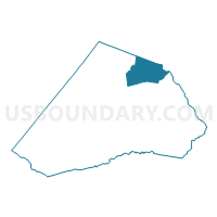
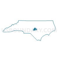
Voting District PR08, Harnett County, North Carolina
About
Outline

Summary
| Unique Area Identifier | 640397 |
| Name | Voting District PR08 |
| County | Harnett County |
| State | North Carolina |
| Area (square miles) | 29.36 |
| Land Area (square miles) | 28.99 |
| Water Area (square miles) | 0.37 |
| % of Land Area | 98.73 |
| % of Water Area | 1.27 |
| Latitude of the Internal Point | 35.49354090 |
| Longtitude of the Internal Point | -78.75134640 |
Maps

Graphs
Select a template below for downloading or customizing gragh for Voting District PR08, Harnett County, North Carolina


Neighbors
Neighoring Voting District (by Name) Neighboring Voting District on the Map
- Voting District 12-02, Wake County, NC
- Voting District 12-04, Wake County, NC
- Voting District 12-06, Wake County, NC
- Voting District PR23, Johnston County, NC
- Voting District PR24, Harnett County, NC
- Voting District PR27, Harnett County, NC
- Voting District PR28, Harnett County, NC
- Voting District PR33, Johnston County, NC
Top 10 Neighboring County Subdivision (by Population) Neighboring County Subdivision on the Map
- Middle Creek township, Wake County, NC (44,136)
- Pleasant Grove township, Johnston County, NC (14,677)
- Grove township, Harnett County, NC (10,911)
- Black River township, Harnett County, NC (10,373)
- Neills Creek township, Harnett County, NC (7,464)
- Hectors Creek township, Harnett County, NC (5,112)
Top 10 Neighboring Place (by Population) Neighboring Place on the Map
Top 10 Neighboring Unified School District (by Population) Neighboring Unified School District on the Map
- Wake County Schools, NC (900,993)
- Johnston County Schools, NC (168,878)
- Harnett County Schools, NC (114,678)
Top 10 Neighboring State Legislative District Lower Chamber (by Population) Neighboring State Legislative District Lower Chamber on the Map
- State House District 37, NC (129,250)
- State House District 28, NC (93,901)
- State House District 53, NC (80,426)
Top 10 Neighboring State Legislative District Upper Chamber (by Population) Neighboring State Legislative District Upper Chamber on the Map
- State Senate District 17, NC (246,945)
- State Senate District 12, NC (210,500)
- State Senate District 22, NC (202,925)
Top 10 Neighboring 111th Congressional District (by Population) Neighboring 111th Congressional District on the Map
Top 10 Neighboring Census Tract (by Population) Neighboring Census Tract on the Map
- Census Tract 531.07, Wake County, NC (8,267)
- Census Tract 415.03, Johnston County, NC (7,075)
- Census Tract 415.02, Johnston County, NC (6,980)
- Census Tract 531.08, Wake County, NC (6,473)
- Census Tract 710.01, Harnett County, NC (5,029)
- Census Tract 704.01, Harnett County, NC (3,963)
- Census Tract 709.04, Harnett County, NC (3,344)
- Census Tract 709.02, Harnett County, NC (2,680)
- Census Tract 709.01, Harnett County, NC (2,574)
- Census Tract 709.03, Harnett County, NC (2,266)